
How Much Does Surveying Equipment Cost?
If you've ever watched a survey crew on your street and wondered what all that gear costs, you're not alone. Professional land surveying is a capital-intensive business. The equipment sitting in our trucks and field cases represents a significant investment — and that investment directly affects the accuracy, speed, and reliability of the survey you receive.
Here's a realistic look at what licensed surveyors spend on equipment, from entry-level total stations to six-figure LiDAR systems — and what it means when you're hiring someone to survey your property in Ohio.
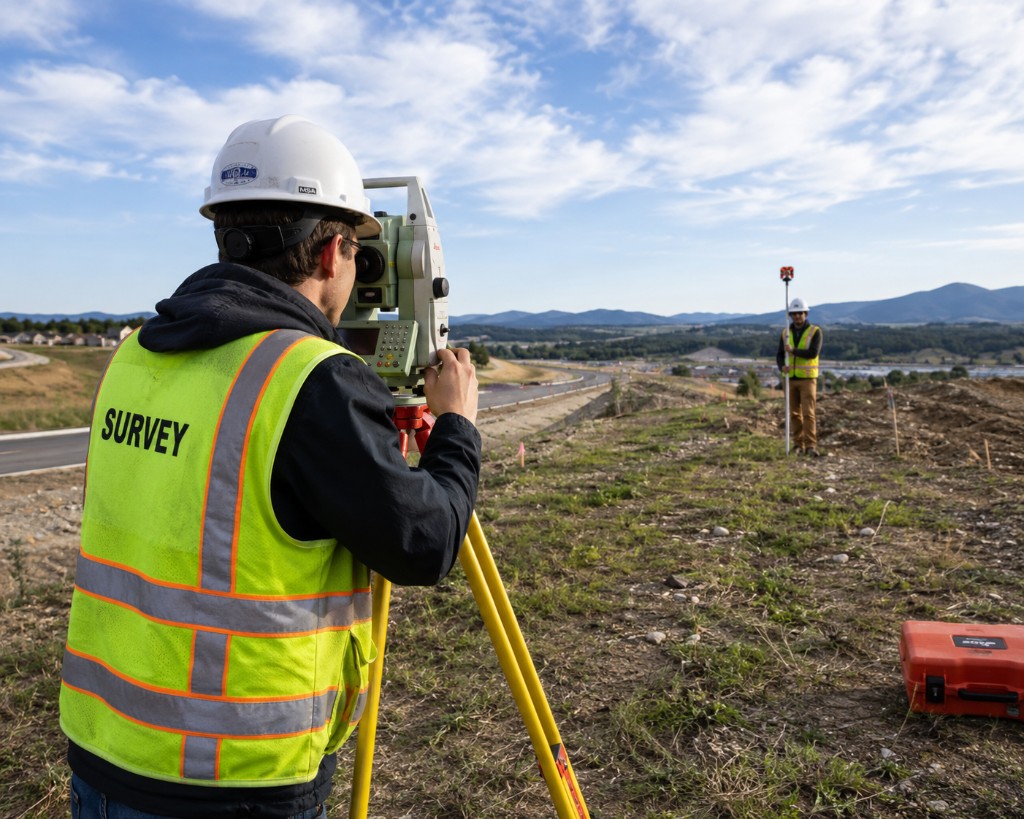
Total Stations: $5,000 – $40,000+
A total station is the workhorse of land surveying. It combines an electronic theodolite (for measuring angles) with an electronic distance meter (for measuring distances) in one instrument. Basic mechanical or entry-level robotic total stations start around $5,000, while high-end robotic total stations with auto-tracking and reflectorless measurement can run $25,000 to $40,000 or more.
Total stations are essential for boundary work, construction layout, and any survey where line-of-sight optical measurement is needed — especially in wooded areas where GPS signals are weak.
GPS/GNSS Receivers: $15,000 – $50,000+
Global Navigation Satellite System (GNSS) receivers are what allow surveyors to achieve centimeter-level accuracy using satellite positioning. A single rover unit might cost $15,000 to $25,000. A complete RTK (Real-Time Kinematic) setup — base station, rover, data collector, and correction service subscription — often totals $30,000 to $50,000+.
At Compass 360 Surveying, GPS/GNSS is central to how we work. It lets us complete field measurements faster and with greater precision than older methods — which is part of how we deliver finished surveys within our 15-business-day guarantee.
Data Collectors and Field Software: $3,000 – $10,000+
The rugged tablet or controller that runs surveying software in the field is easy to overlook, but it's critical. Ruggedized data collectors typically cost $3,000 to $6,000, and the surveying software licenses that power them add $1,000 to $5,000+ per year in subscription fees depending on the platform and modules.
This software handles everything from field data capture to coordinate calculations — the digital backbone that connects what we measure on your lot to the finished plat you receive.
Drones (UAS): $5,000 – $30,000+
Unmanned aerial systems are increasingly used for topographic mapping, large-site surveys, and volumetric work. A survey-grade drone setup — aircraft, camera or LiDAR payload, flight planning software, and FAA Part 107 certification — typically runs $5,000 to $30,000+ depending on capabilities.
Drones aren't needed for every residential boundary survey, but they're valuable for larger commercial sites, construction monitoring, and detailed topographic mapping where traditional ground methods would take much longer.
LiDAR Scanners: $50,000 – $150,000+
Light Detection and Ranging (LiDAR) scanners are among the most expensive tools in a surveyor's arsenal. Terrestrial laser scanners start around $50,000, and high-precision mobile or aerial LiDAR systems can exceed $100,000 — sometimes significantly more when you factor in software, processing hardware, and maintenance.
LiDAR captures millions of data points to create highly detailed 3D models of terrain, buildings, and infrastructure. It's used primarily on complex commercial, industrial, and infrastructure projects rather than typical residential lot surveys.
Supporting Equipment and Ongoing Costs
Beyond the headline instruments, surveyors also invest in:
- Automatic levels and digital levels: $500 – $5,000
- Prisms, rods, and tripods: $500 – $3,000 per field kit
- Survey vehicles and field cases: Ongoing capital expense
- Calibration and maintenance: Required annually to keep instruments within spec
- Insurance and bonding: Professional liability coverage for licensed survey work
When you add it all up, even a small surveying operation can easily have $50,000 to $100,000+ tied up in equipment before the first job is completed.
What This Means for Your Project
Understanding equipment costs helps explain why professional surveying isn't cheap — and why choosing a licensed surveyor with modern, well-maintained equipment matters.
- Accuracy: Current-generation GPS/GNSS and total stations deliver the precision your lender, title company, or building department expects
- Speed: Modern equipment reduces field time, which helps keep your project on schedule
- Legal standing: A signed and sealed plat from a licensed surveyor using calibrated, professional-grade instruments carries weight in court and at the county recorder
- Fair pricing: When you receive a quote from Compass 360, it reflects real field time, research, and the technology required to do the job right — not a shortcut with outdated gear
Curious what a survey on your property will cost? That's a different question — and one we answer every day. See our guide on how much a land survey costs for pricing factors specific to property owners.
Related Resources
Need a Survey?
Call 614-205-0721 or request a free quote. We usually respond within 24 hours.